Out and About
Walking and Cycling
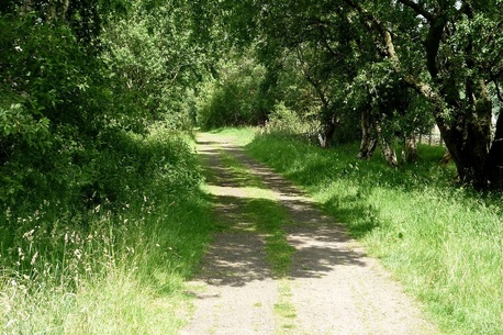
Local Footpaths
Details
Surrounding the hamlet of Eals are several footpaths, which you can see from the large scale map displayed in the hallway. Not all of the footpaths shown on the map are still open or usable.
If you turn left from the front of the Chapel the road becomes a footpath that soon takes you to the river. The bridge at that point shown on the map leads across to link up with the South Tynedale Trail. It was washed away in a flood in May 2013 though it has recently been rebuilt and is now open again.
The footpath from the village does however continue on past the bridge to link up with the South Tyne trail about two miles further on near Lambley, though it is a steep and difficult path in places.
The footpaths around link up to several national trails quite close to, which in turn lead to a maze of other trails and footpaths in and around the Pennines and farther a field.
See also www.walkingworld.com for specific walking ideas
Walking and cycling:
You can also join the South Tynedale trail about 1.5 miles from the ‘Chapel’.
Go right from the cottage and bear right at the end of the road towards Knarsdale.
Turn right just before the church and then right again onto the main road.
Bear right under the bridge, after a few yards there is a path up the bank that take you up onto the Trail.
Go right from the cottage and bear right at the end of the road towards Knarsdale.
Turn right just before the church and then right again onto the main road.
Bear right under the bridge, after a few yards there is a path up the bank that take you up onto the Trail.
If you are on a bicycle or in a car, continue up the main road under the bridge for about 400 yards and there is a turning into a small area in the Trail where you can park your car.
The Trail goes north to Lambley viaduct and on to the site of Featherstone Park Station.
Going south it follows the route of the south Tyne River to Alston.
This trail is in fact an old railway line so the path is quite level, except where it leaves the route of the old railway line for a short way at Lambley viaduct, disrupting cycling.
Walking
|
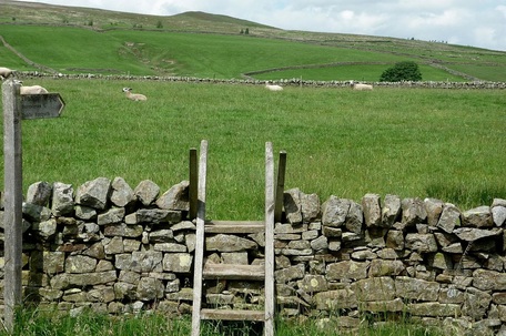
To join the Pennine way, go into Knarsdale as above. The Pennine way joins the A689 just under the bridge;
To go South there is a path from the west side of the road a few yards before the bridge. It continues north from the other side of the bridge, linking up with the Hadrian’s wall trail at ‘Greenhead’. The Pennine Way is 256 miles long altogether and goes from Edale in Derbyshire to Kirk Yetholm on the Scottish Border. |
|
|
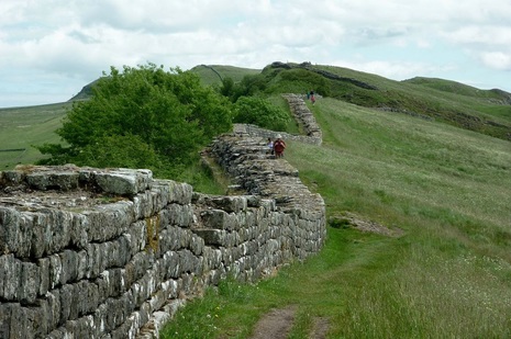
Hadrian Wall Path extends from Bowness-on-Solway in Cumbria for 84 miles to Wallsend on Tyneside,
Passing through spectacular scenery, uneven moor land and hills, past the cities of Carlisle and Newcastle. It has been nominated as Britain’s best long distance trail by 'Countryfile', travelling mostly along the length of Hadrian's Wall, Britain's finest Roman Monument. The nearest point to join the trail is about one mile north of Haltwhistle. |
|
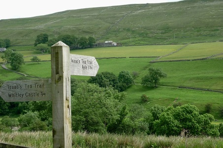
Isaac's Tea Trail is a circular route around Alston, Ninebanks, Allendale, Nenthead and back to Alston.
Isaacs Tea Trail has been referred to as 'England's last undiscovered wilderness trek', over 36 miles in length, it is entirely within the North Pennines area of outstanding natural beauty. The Isaac's Tea Trail links up with the Pennine Way and the South Tyne Trail near Kirkhaugh Station. For more details and an interesting story see www.northumberlandlife.org/teatrail/Page1.asp |
|
Cycling
Even the main roads around the North Pennines are not busy and are usually suitable for cycling, in addition there are many smaller roads that can be all but deserted.
Also there are trails like the South Tyne Trail nearby and many longer distance trails, for example: -
-C2C (from west to east coast),
-Pennine Cycleway,
-The Walney to Wear (and Whitby) National Cycle Routes,
-Wheels to the Wild Cycle Route,
Details and maps for which can be found and downloaded free on line at www.northpennines.org.uk. An Ordinance survey map as displayed in the hallway though should be sufficient for planning your own local trips.
Web sites: - Further details of all these walking and cycling routes and trails can be found on line of course, an example of some sites are suggested below.
These also show some of the historical and recreational facilities that are available in the area, to help you make the most of your holiday: -
- www.touristnetuk.com/north-east-england/northumberland/
- www.sacredsitespodcast.org/gallery
- www.northumberland-walks.co.uk/haltwhistle
- www.gps-routes.co.uk/routes/home.nsf/county-walks/Cumbria
- www.walkengland.org.uk/maps/online-maps.asp
Some Local Places to Visit: -
with approximate mileage from The Chapel
-Lambley Viaduct - 5
-Haltwhistle Leisure Pool - 7
-Hartside Top Cafe on the Alston-Penrith Road - 12
-Hadrian’s Wall with more than a dozen places of interest - 8
-The picturesque village of Alston and the Church - 7
-Hub Heritage & Transport Museum, Alston - 7
-South Tyne Railway - 3.5
-Ashgill Force Waterfall - 11
-The Weardale Valley - 15
-Killhope and Nenthead Mines - 12
-Allenheads Heritage Centre - 18
-Teesdale with ‘High Force’ Waterfall - 25
-Lacy's Caves - 22
-Long Meg Mines - 22
-Long Meg and her Daughters - stone circle - 22
-Talkin Tarn Country Park - 14
-Carlisle Cathedral - 24
-Durham Cathedral - 54
-The Lake District National Park - 29
-Lindisfarne on the east coast - 97
More details of some of these and other specific attractions
are displayed in a selection of tourist leaflets at the cottage,
or many more can be obtained from the Tourist Information
Centre at Alston and in the library at Haltwhistle.
***************************
